AI News
08 May 2026
Read 9 min
how to detect AI-generated satellite imagery in 5 steps
how to detect AI-generated satellite imagery and verify provenance with metadata, multi-source checks
Learn how to detect AI-generated satellite imagery in five clear steps. Check provenance and metadata, cross-verify with other sensors, test scene physics, validate the delivery pipeline, and use AI for forensics. These habits help you reject fakes fast and trust what real satellites saw.
AI makes it easy to alter satellite photos and spread false news. We have seen color added to black-and-white scenes and smoke pasted onto airports that were never on fire. This guide shows you how to detect AI-generated satellite imagery without special tools. Use these steps to cut through noise and confirm what is real.
Check the source. Prefer well-known providers or marketplaces that vet both data and buyers. Be careful with images posted by unknown social accounts.
Read the metadata. Confirm sensor name, capture date and time (UTC), and exact location. If metadata is missing or stripped, treat the image as unverified.
Match sensor capability to the picture. For example, some satellites only shoot black and white. If such an image shows rich color, it is likely altered.
Ask for chain-of-custody details. Look for delivery logs, order IDs, file hashes, or provenance tags (such as C2PA) that show who handled the file from tasking to delivery.
Avoid screenshots. Request the original file from the provider, not a compressed web copy.
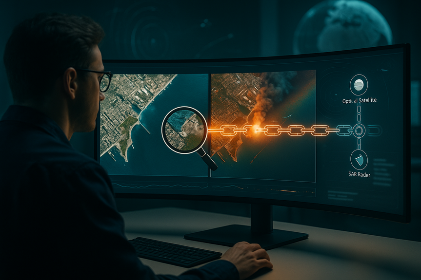
Compare with another satellite. Use a second provider, or check synthetic aperture radar (SAR) if clouds block the view. Independent images of the same time and place should agree on key features.
Validate the satellite’s position. Use public two-line elements (TLEs) or a satellite tracker to see if the claimed satellite could view that spot at that time.
Use other signals. Match the scene with ship AIS tracks, flight data, weather and wind reports, or ground photos and videos from open sources.
Look for location mix-ups. Confirm landmarks and layout. Fakes often mislabel sites or swap bases from different countries.
Check light and shadows. Do building and mast shadows point the same way? Do their lengths fit the sun’s height for that time of day?
Inspect smoke, fire, and debris. Real smoke follows wind and fades with distance. AI smoke often looks too smooth, repeats patterns, or sits on top of objects without natural blending.
Watch for color and sharpness mismatches. Added parts can look too crisp or too blurry compared to the scene. Halos along edges and repeated textures are common signs of editing.
Measure scale. Roads, vehicles, and runways should match known sizes. If the scale feels off, the scene may be composited.
If you want to know how to detect AI-generated satellite imagery quickly, remember this rule: if the physics look wrong, the image likely is too.
Trust systems with controls. Serious providers use secure supply chains, cybersecurity, and customer vetting. Their files carry consistent metadata and delivery notes.
Beware of casual resharing. Many licenses ban image resale. When files pass through many hands, edits and mislabels slip in.
Ask how the image was made. Was it tasked, or pulled from an archive? Who processed it? Simple, clear answers build trust.
Keep a record. Note the source, file name, checks you ran, and your decision. A repeatable workflow protects your team.
Run forensic checks. Use tools that spot editing artifacts, odd noise patterns, or frequency spikes common in synthetic images.
Automate look-alikes. Use visual search to find near-duplicates across catalogs. If a “new” image matches an older one with only color or smoke added, you’ve found a fake.
Compare multi-source data at speed. AI can align SAR, electro‑optical, AIS, and weather layers to confirm or deny a claim in minutes.
Build team literacy. Short training on common tells and a simple triage checklist will catch most problems before they spread.
How to detect AI-generated satellite imagery: 5 reliable steps
Step 1: Verify provenance and metadata
Step 2: Cross-check with independent sources
Step 3: Test the physics and the picture
Step 4: Validate the pipeline, not just the pixel
Step 5: Use AI to fight AI
Why speed and credibility matter
False satellite images can shape headlines, markets, and safety decisions. The good news: there has never been more commercial data to confirm events fast. Industry workflows, clear provenance, and cross-sensor checks make it possible to verify claims within hours, sometimes minutes. AI may help create fakes, but it also boosts your ability to detect them. With these five steps, you now know how to detect AI-generated satellite imagery with confidence. Focus on provenance, cross-checks, physics, pipeline integrity, and smart tools. Do this, and you can trust what you publish, brief, or buy—even as the arms race between fakes and detectors continues.(Source: https://spacenews.com/do-ai-tools-undermine-trust-in-geospatial-imagery/)
For more news: Click Here
FAQ
Q: What are the five steps for how to detect AI-generated satellite imagery?
A: The five steps are to verify provenance and metadata, cross-check with independent sources, test scene physics, validate the delivery pipeline, and use AI-enabled forensics. Following these steps helps you reject fakes quickly and trust what real satellites observed.
Q: How does checking provenance and metadata reveal altered satellite images?
A: Check the source and read the metadata to confirm sensor name, capture date and time (UTC), and precise location, since missing or stripped metadata indicates an unverified image. Also match sensor capability to the picture (for example, a satellite that only collects black-and-white should not produce a color scene) and ask for chain-of-custody details or the original file rather than a screenshot.
Q: What independent sources should I use to cross-verify a suspicious satellite image?
A: Compare the image with other satellite providers or different sensor types such as synthetic aperture radar (SAR), and check signals like AIS ship tracks, flight data, weather reports, and ground photos or videos. Validate the claimed satellite’s position against public two-line elements (TLEs) or a satellite tracker to confirm it could have viewed that spot at the stated time.
Q: What physical signs in an image suggest AI manipulation?
A: Inspect lighting and shadows to see if they point consistently and match the sun’s angle for the time of day, and watch for smoke or fire that ignores wind or fades unnaturally. Also look for color or sharpness mismatches, halos along edges, repeated textures, and scale inconsistencies between known objects that indicate compositing.
Q: How should I validate the delivery pipeline to ensure an image wasn’t altered?
A: Verify chain-of-custody information, delivery logs, order IDs and file hashes or provenance tags to ensure nobody outside the organization touched the image. Ask whether the file was tasked or pulled from an archive, prefer vendors with secure supply chains and customer vetting, and keep a record of sources and checks as a repeatable workflow.
Q: Can AI tools help detect AI-generated or altered satellite imagery?
A: Yes, AI can speed up detection by spotting editing artifacts, odd noise patterns or frequency spikes and by automating visual searches for near-duplicates across catalogs. AI can also align multi-source data such as SAR, electro-optical, AIS and weather layers to confirm or deny claims quickly.
Q: Why does source credibility and vendor control matter when trusting satellite images?
A: Reputable providers deliver extensive metadata and provenance, enforce customer vetting and demonstrate cybersecurity and supply-chain controls that increase confidence an image has not been altered. When images are reshared casually or come from unknown accounts, the chances of edits or mislabels increase, so relying on trusted vendors reduces that risk.
Q: How quickly can these verification methods expose falsified images and why does speed matter?
A: Because commercial imagery and multi-source data are widely available, cross-sensor checks and provenance validation can often verify or debunk claims within hours or sometimes minutes. Speed matters because false satellite images can shape headlines, markets and safety decisions, so rapid verification helps limit misinformation and harm.
Contents